interviews & profiles
Thru-Hiking the Pacific Crest Trail
Dec 17, 2006
Let's just say that you're one of the 300 really committed, perhaps even foolhardy, outdoor types who decide each year to attempt to hike the entire length of the Pacific Crest Trail (PCT), which runs from the United States border with Mexico to its border with Canada and follows the highest portion of the Sierra Nevada and Cascade Range.
You will need to cover 2,650 miles, knock off 300,000 feet of elevation gain, and be able to carve out enough room on your calendar for about five or six months. That's the easy part. Then there's blistering heat in the south, snow-covered passes, blood-sucking mosquitos, constant food resupplying, aching feet, and sheer physical and mental exhaustion.
Little wonder that the average annual drop-out rate for PCT thru-hikers is a staggering 50%. Still, completing the Pacific Crest Trail represents one-third of America's holy grail of long-distance hiking. (The Appalachian Trail and the Continental Divide Trail form the rest of the "Triple Crown").
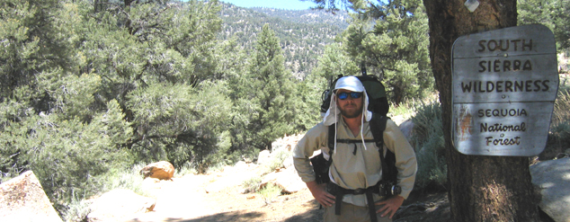
In 2005, self-employed commercial photographer Jason Waicunas and his college buddy, Matt Lee, successfully thru-hiked the Pacific Crest Trail. RailRiders spoke with the Portland, Oregon resident in late November, 2010. "I still wear the same pair of Weatherpants and Eco-Mesh Shirt that I used during the PCT, "says Waicunas who likes squeezing in occasional 10-15 mile days on the trail. "Both have held up great, and I still hike in the same RR clothes I hiked in back in 2005."
Q: What got you first interested in hiking the Pacific Crest Trail?
JW: The idea to hike the PCT came about a couple of years ago when my uncle Bob and I visited the Slate Peak and Hart's Pass area in the Northern Cascades of Washington state. At the summit I saw a trail that meandered into the distance and asked, "Where does it go?" My uncle's reply caught my attention. He said, "That is the Pacific Crest Trail, which runs from Mexico to Canada." After pondering the distance and doing some research, I decided to attempt to thru-hike the PCT in 2005 with Matt who I met at Old Dominion University. As an avid hiker and a photographer, the purpose to hike the trail was both a personal mission and a professional project. By hiking the trail and telling the story through images, writing, and audio recordings, my goal was to create a documentary based on the experience and to share it with other people. Although I obtained a lot of great content, it was too big of a feat to create a solid documentary in tandem with my first long-distance hike and I hope to return to the PCT to complete the task. To be expected, our families were a bit concerned for our safety, especially in a year that record levels of snowfall had fallen in the Sierra Nevada, but we promised to check in by calling when we reached town stops.
Q: How did you prepare for the PCT thru-hike?
JW: Before setting out on the trail, I was in good hiking condition and had an above average level of hiking experience. Matt, had never hiked any significant distance before attempting to hike the PCT, but despite our differences, we both acclimated to it over time. Most of the physical preparation took place on the trail because we didn't have the time to hike twenty or more miles each day prior to hitting the trail. The insanity of planning and preparation masked what we were getting into and the reality of it all hit us on our first day out.
Q: Describe your gear-- what did you take?
JW: At first, we had far too much gear in our packs, which happened to be the case for most of the hikers who had never attempted to do a thru-hike before. The rule out there is: "Every Ounce of Weight Counts!" So we eventually got rid of the non-essential items. Matt and I shared certain gear items, so we balanced our packs to weigh proportionally to our body weight, although I carried about eight pounds of camera equipment and gear.
Essential gear included: synthetic nylon RailRiders Weatherpants and Eco-Mesh shirts, Mont-bell down jacket liners and nylon rain gear, Columbia Kvichak fleece hats, Patagonia capilene long underwear, various types of shoes (we went through five pairs each), Darn Tough wool / nylon blended socks, Golite reflective umbrellas (in the desert), a Katadyn Hiker Pro pump for water purification, AquaFina plastic bottles, MSR 5-liter dromedary bags with hydration tubes, an MSR International tri-fuel stove and a steel 11.6 oz. MSR cook pot, lexan spoons and forks, a Victorinox Swiss Army Classic knife, Osprey Aether 90 packs, Marmot Helium 15 degree-rated sleeping bags, Therm-a-Rest foam sleeping pads, Stubai ice axes and Kahtoola crampons for the Sierra Nevadas, Black Diamond headlamps, OR mosquito head nets, Julbo Sherpa UV sunglasses, OR stuff sacks, Brunton 3DLU compass, Adventure Medical First Aid Kits, duct tape for repairs and first aid, maps and guidebook pages, a sheet of Tyvek to sleep on during good weather and as a footprint for our tent, a Hilleberg Nallo 3 four-season tent, and the most important of all, toilet paper!
Q: When did you start?
JW: High noon, April 29, 2005 at the southern terminus of the PCT in Campo, California, (on the border with Mexico.)
Q: When did you finish?
JW: October 8, 2005 at Manning Park, in British Columbia, Canada. The hike took us five months and two weeks to complete.
Q: What were the toughest days of the trip?
JW: The first few weeks were tough on us physically because our bodies were in shock from the daily mileage, the change of diet, and acclimating to living in the outdoors. The last day was the hardest for me, because although it was an accomplishment to have finished our journey, it was hard to leave the trail.
Q: Did you have days when you wanted to quit?
JW: I didn't ever want to quit, but I considered that I may have been forced to quit due to a torn leg muscle injury, (IT band), I got in the Sierras which could have ended my hike. If I had not taken two weeks to get off of the trail and to rest, I probably wouldn't have made it otherwise.
Q: How did you manage resupplies?
JW: We bought food when we reached the trail towns, but if we knew that a particular town didn't have a grocery store, then we would mail food to ourselves by sending packages to post offices and places of business in towns that were near the trail. Additionally, when we wanted to get rid of something that we might need later, we would ship it the same way.
Q: What was your favorite sections of the PCT?
JW: I have three favorite sections. Crabtree Meadows in the Sierras of California is an area surrounded by sheer cliff walls, trout streams meandering through marshy meadows where deer feed, and countless photographic opportunities. In Oregon, the alpine lakes and volcanic rock formations within the Mt. Jefferson wilderness area blew my mind....I really hope to summit Mt. Jefferson someday. The North Cascades of Washington were special to me because that it's where I was introduced to the trail and they offer incredible vistas.
Q: What significant challenges awaited you during different sections?
JW: The desert regions were tough because we had to carry water for long distances; there were 15+ mile sections of trail with no water, and the hazards of snakes and excessive heat made us uneasy at times. During the winter prior to our hike, the Sierras received record levels of snow, which had not melted off like it does in most years. As a result, a lot of hikers were forced to quit or skipped ahead to Canada and changed their northbound hike to a southbound one. We chose to go north and the snow was really tough in certain sections. By this point, we felt strong and fit. We stuck it out, deciding to try and haul our 70-pound packs for 210 miles, the longest section of any trail in the United States that doesn't cross a road. Outfitted with crampons, ice axes, cold weather gear, and enough food to feed a family for two weeks, we headed out of town into the Sierra wilderness that was as unforgiving as the desert, but the most beautiful spectacle I have ever seen. We often maintained an elevation of 11,000 feet or more while passing through extensive snowfields and high, icy passes, but my fear was overshadowed by my awe. About 1/3 of the way, my leg was so bad I had to get off the trail to take a two week break to recover. At the same time, Matt felt he needed to rest due to skin irritations and a sore foot. After we recovered we resumed our hike at the point where we would have reached if we had continued for two weeks of hiking.
Q: How many other thru-hikers did you meet along the way?
JW: Maybe about 100 or so. You could never meet everyone who is hiking in one year due to the varied times of starting the hike, pace, and so on. They are doctors, teachers, artists, retirees, college students, dispatchers, cooks. All walks of life are represented on the trail. Only about a third of the 300 people who attempted to hike the PCT in 2005 made it.
Q: Did you hike with others?
JW: Yes. We hiked with a few people at various intervals along the way. Sometimes it was just Matt and I for several days, and on other days therewere as many as ten of us. Thru-hiking is such a random thing in that you never know when you will see someone, whether it's on the trail or in a town. Due to varying hiking speeds, ailments, or extended town stops, the ebb and flow of who we hiked with changed often, but as we spent days, weeks, or even months with them, we all got to know each other very well. Many of them have great stories, ranging from the night a bear entered the vestibule of a hiker's tent and stole his pack to getting rides to towns from ex-cons.
Q: Tell me about your hiking partner
JW: Matt, whose trail named was "Chowder," (mine was "NaborJ") and I met at an Allman Brothers concert back in 1998. After college, Matt spent a little over two years in the Peace Corps in Mongolia. While he was there, I sent him books on the PCT and harassed him with emails and letters asking if he wanted to hike the trail when he returned to the U.S. I hope to do another long-distance hike with him again someday.
Q: How did you get along? And conflicts along the way? Or was it smooth sailing?
JW: For the most part, we had a great time, but there were instances that we didn't get along when we were physically hurt or exhausted. We had one scary moment when we decided to slide down a short section on Mt. Whitney. Someone had died doing the same thing earlier in the year, but because I was hurt with my leg injury and I needed to get to a hospital, we slid down the snow-covered slope on our butts. Yet we first exchanged heated words, but it never got farther than that. Normally, we hiked at the same pace, but there were times when I didn't want to stop and wanted to keep on going; Matt would then got really pissed off at me for being a "slave driver."
Q: Did you ever get lost?
JW: We didn't get lost, but there were a few sections where the trail was buried under five to fifteen feet of snow. We used a map and compass to get our bearings. Even though we were okay, that feeling of uncertainty really makes you pay attention to what you are doing out there.
Q: The average miles per day?
JW: 22 miles.
Q: Longest day?
JW: 29 miles.
Q: Any rest days?
JW: We spent several days in certain spots along the trail; sometimes we got to a spot where we decided to take in the sights or to rest. Also, we spent several days in trail towns along the way.
Q: How much body weight did you lose?
JW: I lost twenty pounds. Prior to hiking the trail, I had put on about ten pounds of beer and pizza weight, so I didn't mind losing that weight, but the additional ten pounds I lost made me too thin.
Q: Ah, the mosquitos. Aren't they numerous and ferocious right around the John Muir section near Yosemite? How did you cope with them?
JW: Mosquitos are by far the most horrible living organism on the planet. They were bad in the Sierras and we used mosquito head nets to protect ourselves. Matt found out that burning dried horse poop drove away mosquitos!
Q: Any encounters with animals like black bears and mountain lions?
JW: I was once hiking about fifty yards ahead of Matt, going at a fast pace and when I looked up there was a black bear about twenty yards in front of me. The bear and I then ran in opposite directions. There were a few other bear sightings, but from afar. We didn't see any mountain lions.
Q: How did your RailRiders hold up? What do you like best about them?
JW: The RailRiders Weatherpants and Eco-Mesh Shirts did us well on the trail. We beat the hell out of our clothes and they held up to an incredible amount of abuse out there. I like the fact that they are comfortable, lightweight, and that they are made by a small company that stands by their product. I have well over 2,000 miles logged in my Weatherpants and Eco-Mesh Shirt. I continue to use both. Yet I should mention that at Porcupine Lake in Northern California, I was trying to dry out my Eco-Mesh Shirt by a fire and a few stray embers caught the sleeves on fire. The sleeves were totally gone, while a few stray burn holes were left on the shirt front. So I wound up cutting off the sleeves and making it an "Eco-Mesh Tanktop." I still hike in it to this day.
Q. Who are trail angels and how did they assist you and other thru-hikers?
JW: Trail angels are people who go out of their way to help hikers in many ways. Some of them carry in large amounts of water and set them at water caches in areas where water sources are bad or non-existent. Also, there are those who take dirty, stinky hikers into their homes and offer them a place to stay for as long as needed. They are truly special people.
Q: Any new long-distance thru-hikes you're planning to accomplish?
JW: l hope to hike the PCT again so that I can complete a photography / video project that I wasn't able to finish in 2005. It will be interesting to compare and contrast how the trail, the trail towns, and the people may have changed over time, including myself. Hiking a long-distance trail is a lot like life: you can look back and see how you've changed and everything ahead is all but a mystery.
To read a detailed account of Jason and Matt's PCT thru-hike experience, go to www.trailjournals.com and search under "NaborJ" or "Chowder." To see some of Jason's photos from the hike, you may visit the "Projects" link within his website, https://www.jasonsvision.com/